
Ios topographic map
Click on the map to display elevation.
Ios
The highest elevation (723 m, 2372 ft) is the Kastro (Greek: Κάστρο) peak also called Pyrgos (Greek: Πύργος), located in the center of the island, while around the Kastro are the next three Highest peaks: Xylodema (Greek: Ξυλόδεμα) (660 m, 2165 ft), Kostiza (Greek: Κοστίζα) (586 m, 1923 ft) and Prophetis Elias (Greek: Προφήτης Ηλίας) (490 m, 951 ft).
About this map
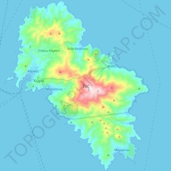
Name: Ios topographic map, elevation, terrain.
Location: Ios, Thira Regional Unit, South Aegean, Aegean, 840 01, Greece (36.64210 25.24594 36.79255 25.40308)
Average elevation: 240 ft
Minimum elevation: -3 ft
Maximum elevation: 2,352 ft
Other topographic maps
Click on a map to view its topography, its elevation and its terrain.
Old Port Fira
Greece > Aegean > Thira Regional Unit > Thira Municipal Unit > Fira
Average elevation: 285 ft
Oia
Greece > Aegean > Thira Regional Unit > Ia Municipal Unit
The village is located on top of a hill, at about 150 m (500 ft) elevation, and known as the "Eagles nest" from where Palia and Nea Kameni volcanoes are seen and also the island of Therasia. It is situated to the north of the island and Fira is at distance of 11 km (7 mi). The main street in the town, in the…
Average elevation: 66 ft