
Make a donation
Gear up for your next adventure:
As an Amazon Associate, this site earns from qualifying purchases at no extra cost to you.
Rehme topographic map
Click on the map to display elevation.
Make a donation
Gear up for your next adventure:
As an Amazon Associate, this site earns from qualifying purchases at no extra cost to you.
About this map
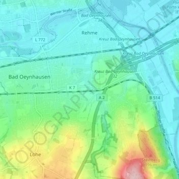
Name: Rehme topographic map, elevation, terrain.
Average elevation: 282 ft
Minimum elevation: 135 ft
Maximum elevation: 781 ft
Make a donation
Gear up for your next adventure:
As an Amazon Associate, this site earns from qualifying purchases at no extra cost to you.
Other topographic maps
Click on a map to view its topography, its elevation and its terrain.
Röhn
Deutschland > Nordrhein-Westfalen > Kreis Minden-Lübbecke > Bad Oeynhausen
Average elevation: 335 ft
Bergkirchen
Deutschland > Nordrhein-Westfalen > Kreis Minden-Lübbecke > Bad Oeynhausen
Die Wohnbaufläche Bergkirchens liegt überwiegend am Fuße des Bergkirchener Kopfes, nimmt aber auch mit dem Ortskern die Passhöhe zwischen diesem und dem Rothenuffler Berg ein. Bergkirchen ist, insbesondere mit seinem Kirchturm, die einzige Ortschaft, die von beiden Seiten des Gebirges von Weitem sichtbar…
Average elevation: 377 ft
Wietel
Deutschland > Nordrhein-Westfalen > Kreis Minden-Lübbecke > Bad Oeynhausen
Average elevation: 292 ft
Siedinghausen
Deutschland > Nordrhein-Westfalen > Kreis Minden-Lübbecke > Bad Oeynhausen
Average elevation: 397 ft
Make a donation
Gear up for your next adventure:
As an Amazon Associate, this site earns from qualifying purchases at no extra cost to you.
Kappenberg
Deutschland > Nordrhein-Westfalen > Kreis Minden-Lübbecke > Bad Oeynhausen
Average elevation: 390 ft
Wittekindshof
Deutschland > Nordrhein-Westfalen > Kreis Minden-Lübbecke > Bad Oeynhausen > Bergkirchen
Average elevation: 377 ft
Oberbecksen
Deutschland > Nordrhein-Westfalen > Kreis Minden-Lübbecke > Bad Oeynhausen > Oberbecksen
Average elevation: 289 ft
Kurpark
Deutschland > Nordrhein-Westfalen > Kreis Minden-Lübbecke > Bad Oeynhausen
Average elevation: 240 ft
Make a donation
Gear up for your next adventure:
As an Amazon Associate, this site earns from qualifying purchases at no extra cost to you.
Plattenberg
Deutschland > Nordrhein-Westfalen > Kreis Minden-Lübbecke > Bad Oeynhausen
Average elevation: 325 ft