
Make a donation
Gear up for your next adventure:
As an Amazon Associate, this site earns from qualifying purchases at no extra cost to you.
Wietel topographic map
Click on the map to display elevation.
Make a donation
Gear up for your next adventure:
As an Amazon Associate, this site earns from qualifying purchases at no extra cost to you.
About this map
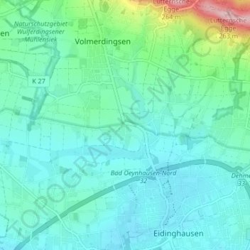
Name: Wietel topographic map, elevation, terrain.
Average elevation: 292 ft
Minimum elevation: 174 ft
Maximum elevation: 823 ft
Make a donation
Gear up for your next adventure:
As an Amazon Associate, this site earns from qualifying purchases at no extra cost to you.
Other topographic maps
Click on a map to view its topography, its elevation and its terrain.
32549
Deutschland > Nordrhein-Westfalen > Kreis Minden-Lübbecke > Bad Oeynhausen
Average elevation: 272 ft
Lohe
Deutschland > Nordrhein-Westfalen > Kreis Minden-Lübbecke > Bad Oeynhausen
Das nördliche Gebiet des Stadtteils Lohe liegt im flachwelligen Oeynhausener Hügelland, einem Teilbereich des Ravensberger Hügellands, das von Bächen teilweise stark zertalt ist; typisch sind die als Sieke bezeichneten Kastentälchen. Der nördliche Teil der Fläche wird von Gestein des Unteren Jura (Lias)…
Average elevation: 476 ft
Bad Oeynhausen
Deutschland > Nordrhein-Westfalen > Kreis Minden-Lübbecke > Bad Oeynhausen
Average elevation: 279 ft
32547
Deutschland > Nordrhein-Westfalen > Kreis Minden-Lübbecke > Bad Oeynhausen
Average elevation: 272 ft
Make a donation
Gear up for your next adventure:
As an Amazon Associate, this site earns from qualifying purchases at no extra cost to you.
Volmerdingsen
Deutschland > Nordrhein-Westfalen > Kreis Minden-Lübbecke > Bad Oeynhausen
Average elevation: 348 ft
Rehme
Deutschland > Nordrhein-Westfalen > Kreis Minden-Lübbecke > Bad Oeynhausen
Average elevation: 282 ft
Kurpark
Deutschland > Nordrhein-Westfalen > Kreis Minden-Lübbecke > Bad Oeynhausen
Average elevation: 240 ft