Geolocate

Winlock topographic map

Click on the map to display elevation.

Winlock

The eastern edge of the Willapa Hills lie to the west. To the east are relatively flat prairies. A notable landmark about four miles west of town is Sam Henry Mountain, elevation 1,492 feet (455 m), named for an early section superintendent of the Northern Pacific Railroad. Mt. St. Helens, about forty miles (64.4 km) to the east can be seen from viewpoints around the area. In May 1980, Winlock was covered with about one inch (2.54 cm) of volcanic ash from the second major eruption of this peak one week after the cataclysmic eruption of May 18.

Wikipedia (CC-BY-SA 3.0)

About this map

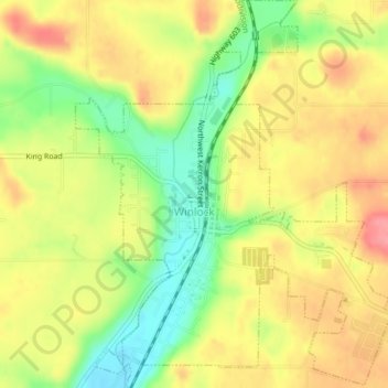
Name: Winlock topographic map, elevation, terrain.

Location: Winlock, Lewis County, Washington, United States (46.48013 -122.95086 46.50712 -122.91892)

Average elevation: 407 ft

Minimum elevation: 256 ft

Maximum elevation: 531 ft

Lewis County trails, hiking, mountain biking, running and outdoor activities

Other topographic maps

Click on a map to view its topography, its elevation and its terrain.

Cinebar

United States > Washington > Lewis County

Average elevation: 1,010 ft

Randle

United States > Washington > Lewis County

Average elevation: 1,240 ft

The Rockies

United States > Washington > Lewis County

Average elevation: 3,320 ft

Silver Falls

United States > Washington > Lewis County

Average elevation: 2,779 ft

Angry Mountain

United States > Washington > Lewis County

Average elevation: 4,596 ft

Mayfield

United States > Washington > Lewis County

Average elevation: 732 ft

Bunker

United States > Washington > Lewis County

Average elevation: 331 ft

Glenoma

United States > Washington > Lewis County

Average elevation: 1,161 ft

Packwood

United States > Washington > Lewis County

Average elevation: 1,243 ft

Adna

United States > Washington > Lewis County

Average elevation: 269 ft

Ceres

United States > Washington > Lewis County

Average elevation: 404 ft

Randle

United States > Washington > Lewis County

Average elevation: 1,240 ft

Onalaska

United States > Washington > Lewis County

Average elevation: 558 ft

The Rockies

United States > Washington > Lewis County

Average elevation: 3,320 ft

Ham Hill

United States > Washington > Lewis County > Centralia

Average elevation: 331 ft

Gear up for your next adventure:

🧭Compass with Lanyard - Easy‑carry compass for navigation
🎒Day Hiking Backpack - Lightweight backpack perfect for day trips and outdoor adventures
🔪Outdoor Multitools - Essential survival tools for gear repair and field use
📚Navigation Handbooks - Master the art of reading topographic maps and using a compass
🌡️Portable Weather Meter - Track weather conditions on the trail

As an Amazon Associate, this site earns from qualifying purchases at no extra cost to you.