Geolocate

St. Albert topographic map

Click on the map to display elevation.

About this map

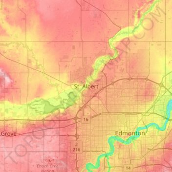
Name: St. Albert topographic map, elevation, terrain.

Location: St. Albert, Alberta, T8N 3Z9, Canada (53.47324 -113.78885 53.79324 -113.46885)

Average elevation: 2,234 ft

Minimum elevation: 1,995 ft

Maximum elevation: 2,411 ft

Other topographic maps

Click on a map to view its topography, its elevation and its terrain.

Riverlot 56 Natural Area

Canada > Alberta > St. Albert > St. Albert

Average elevation: 2,211 ft

Gear up for your next adventure:

🔥Fast-Boil Camping Stoves - Efficient cooking systems for quick trail meals
Backpacking Tents - Weight-optimized shelters for multi-day topographic surveys
🧣Hiking Neck Gaiter - Multi‑use neck protection for outdoor weather
🪶Survival Guide Book - Expert advice for emergency preparedness
🕶️Glacier Sunglasses - Side shields to protect eyes from high-altitude snow glare

As an Amazon Associate, this site earns from qualifying purchases at no extra cost to you.