
Make a donation
Gear up for your next adventure:
As an Amazon Associate, this site earns from qualifying purchases at no extra cost to you.
Austin topographic map
Click on the map to display elevation.
Make a donation
Gear up for your next adventure:
As an Amazon Associate, this site earns from qualifying purchases at no extra cost to you.
About this map
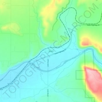
Name: Austin topographic map, elevation, terrain.
Location: Austin, Delta County, Colorado, 81410, United States (38.76109 -107.97090 38.80109 -107.93090)
Average elevation: 5,171 ft
Minimum elevation: 4,997 ft
Maximum elevation: 5,636 ft
Delta County trails, hiking, mountain biking, running and outdoor activities
Make a donation
Gear up for your next adventure:
As an Amazon Associate, this site earns from qualifying purchases at no extra cost to you.
Other topographic maps
Click on a map to view its topography, its elevation and its terrain.
Cedaredge
United States > Colorado > Delta County
Located in a protected valley at 6,100 feet (1,900 m) in elevation, the Cedaredge Golf Club course has natural cedars and winding creek beds.
Average elevation: 6,178 ft
Make a donation
Gear up for your next adventure:
As an Amazon Associate, this site earns from qualifying purchases at no extra cost to you.