
Owls Head topographic map
Click on the map to display elevation.
About this map
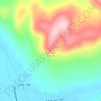
Name: Owls Head topographic map, elevation, terrain.
Average elevation: 1,818 ft
Minimum elevation: 1,496 ft
Maximum elevation: 2,349 ft
Franklin County trails, hiking, mountain biking, running and outdoor activities
Other topographic maps
Click on a map to view its topography, its elevation and its terrain.
Village of Saranac Lake
United States > New York > Franklin County > Town of Harrietstown
Average elevation: 1,647 ft
Rollins Pond
United States > New York > Franklin County > Town of Tupper Lake > Town of Santa Clara
Average elevation: 1,614 ft
Fish Creek Pond
United States > New York > Franklin County > Town of Santa Clara
Average elevation: 1,611 ft
Fish Creek Pond Campground
United States > New York > Franklin County > Town of Santa Clara
Average elevation: 1,601 ft
Village of Saranac Lake
United States > New York > Franklin County > Town of Harrietstown
Average elevation: 1,647 ft
Town of Chateaugay
United States > New York > Franklin County > Town of Chateaugay
Average elevation: 919 ft