
Make a donation
Gear up for your next adventure:
As an Amazon Associate, this site earns from qualifying purchases at no extra cost to you.
Rainbow Lake topographic map
Click on the map to display elevation.
Make a donation
Gear up for your next adventure:
As an Amazon Associate, this site earns from qualifying purchases at no extra cost to you.
About this map
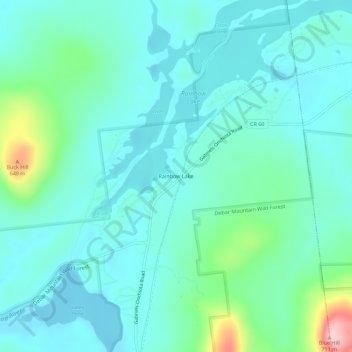
Name: Rainbow Lake topographic map, elevation, terrain.
Average elevation: 1,759 ft
Minimum elevation: 1,634 ft
Maximum elevation: 2,300 ft
Franklin County trails, hiking, mountain biking, running and outdoor activities
Make a donation
Gear up for your next adventure:
As an Amazon Associate, this site earns from qualifying purchases at no extra cost to you.
Other topographic maps
Click on a map to view its topography, its elevation and its terrain.
Upper Saint Regis Lake
United States > New York > Franklin County > Town of Harrietstown
Average elevation: 1,660 ft
Make a donation
Gear up for your next adventure:
As an Amazon Associate, this site earns from qualifying purchases at no extra cost to you.
Make a donation
Gear up for your next adventure:
As an Amazon Associate, this site earns from qualifying purchases at no extra cost to you.
Mountain View Lake
United States > New York > Franklin County > Mountain View
Average elevation: 1,549 ft
Fish Creek Pond Campground
United States > New York > Franklin County > Santa Clara
Average elevation: 1,601 ft
Make a donation
Gear up for your next adventure:
As an Amazon Associate, this site earns from qualifying purchases at no extra cost to you.
Lower Chateaugay Lake
United States > New York > Franklin County > Town of Ellenburg
Average elevation: 1,598 ft
Meacham Lake
United States > New York > Franklin County
Meacham Lake is a 1,203-acre (4.87 km2) lake eight miles north of Paul Smiths in Franklin County, New York in the Adirondack Park. It is 2 miles (3.2 km) long, north to south, and 1 mile (1.6 km) wide. The lake is found at an elevation of 1,552 feet (473 m). Most of the lake is in the town of Duane; the…
Average elevation: 1,604 ft
Make a donation
Gear up for your next adventure:
As an Amazon Associate, this site earns from qualifying purchases at no extra cost to you.
Make a donation
Gear up for your next adventure:
As an Amazon Associate, this site earns from qualifying purchases at no extra cost to you.