
Make a donation
Gear up for your next adventure:
As an Amazon Associate, this site earns from qualifying purchases at no extra cost to you.
Malvern topographic map
Click on the map to display elevation.
Make a donation
Gear up for your next adventure:
As an Amazon Associate, this site earns from qualifying purchases at no extra cost to you.
About this map
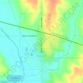
Name: Malvern topographic map, elevation, terrain.
Location: Malvern, Mills County, Iowa, United States (40.99799 -95.59452 41.01627 -95.57244)
Average elevation: 1,040 ft
Minimum elevation: 981 ft
Maximum elevation: 1,145 ft
Mills County trails, hiking, mountain biking, running and outdoor activities
Make a donation
Gear up for your next adventure:
As an Amazon Associate, this site earns from qualifying purchases at no extra cost to you.
Other topographic maps
Click on a map to view its topography, its elevation and its terrain.
Silver City
United States > Iowa > Mills County > Silver City > Silver City
Average elevation: 1,115 ft