
Guimerà topographic map
Interactive map
Click on the map to display elevation.
About this map
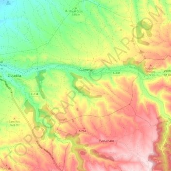
Name: Guimerà topographic map, elevation, terrain.
Location: Guimerà, Urgel, Lérida, Catalogne, 25341, Espagne (41.51792 1.15353 41.59660 1.21960)
Average elevation: 1,965 ft
Minimum elevation: 1,375 ft
Maximum elevation: 2,556 ft
Other topographic maps
Click on a map to view its topography, its elevation and its terrain.