
Make a donation
Gear up for your next adventure:
As an Amazon Associate, this site earns from qualifying purchases at no extra cost to you.
Ola topographic map
Click on the map to display elevation.
Make a donation
Gear up for your next adventure:
As an Amazon Associate, this site earns from qualifying purchases at no extra cost to you.
About this map
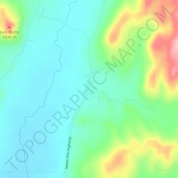
Name: Ola topographic map, elevation, terrain.
Location: Ola, Gem County, Idaho, United States (44.16796 -116.30294 44.18796 -116.28294)
Average elevation: 3,094 ft
Minimum elevation: 2,943 ft
Maximum elevation: 3,484 ft
Gem County trails, hiking, mountain biking, running and outdoor activities
Make a donation
Gear up for your next adventure:
As an Amazon Associate, this site earns from qualifying purchases at no extra cost to you.
Other topographic maps
Click on a map to view its topography, its elevation and its terrain.
Emmett
United States > Idaho > Gem County
According to the United States Census Bureau, the city has a total area of 2.82 square miles (7.30 km2), of which 2.80 square miles (7.25 km2) is land and 0.02 square miles (0.05 km2) is water. It is located south of the Payette River, at an elevation of 2,362 feet (720 m) above sea level.
Average elevation: 2,421 ft