Geolocate

Garden Ridge topographic map

Click on the map to display elevation.

About this map

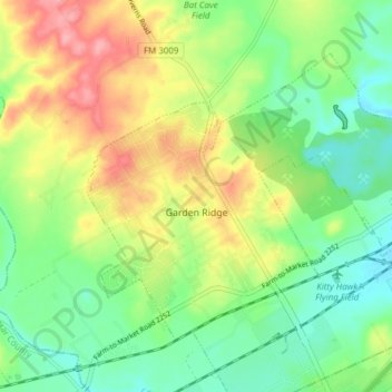
Name: Garden Ridge topographic map, elevation, terrain.

Location: Garden Ridge, Comal County, Texas, 78266, United States (29.61304 -98.32677 29.66157 -98.25044)

Average elevation: 863 ft

Minimum elevation: 732 ft

Maximum elevation: 1,060 ft

Comal County trails, hiking, mountain biking, running and outdoor activities

Other topographic maps

Click on a map to view its topography, its elevation and its terrain.

Canyon Lake

United States > Texas > Comal County

Average elevation: 971 ft

Gruene

United States > Texas > Comal County > New Braunfels

Average elevation: 689 ft

Sattler

United States > Texas > Comal County

Average elevation: 869 ft

Startzville

United States > Texas > Comal County

Average elevation: 1,093 ft

Anhalt

United States > Texas > Comal County > Bulverde

Average elevation: 1,302 ft

Thorn Hill

United States > Texas > Comal County > New Braunfels

Average elevation: 699 ft

Preiss Heights

United States > Texas > Comal County

Average elevation: 702 ft

Natural Bridge Caverns

United States > Texas > Comal County

Average elevation: 1,047 ft

Startzville

United States > Texas > Comal County

Average elevation: 1,093 ft

Gruene

United States > Texas > Comal County > New Braunfels

Average elevation: 689 ft

Canyon Springs

United States > Texas > Comal County

Average elevation: 1,017 ft

Gear up for your next adventure:

🔭Stargazing Telescopes - Perfect for camping in low-light pollution areas shown on maps
📡Handheld GPS Device - Reliable handheld GPS for outdoor navigation
🧺Microfiber Travel Towels - Compact and fast-drying towels for trail use
👖Convertible Hiking Pants - Versatile zip-off pants for changing altitudes and temperatures
📌Outdoor GPS Map App - Apps and devices for digital topographic navigation

As an Amazon Associate, this site earns from qualifying purchases at no extra cost to you.