
Thank you for supporting this site ❤️
Make a donation
Make a donation
Gear up for your next adventure:
As an Amazon Associate, this site earns from qualifying purchases at no extra cost to you.
Mernes topographic map
Click on the map to display elevation.
Thank you for supporting this site ❤️
Make a donation
Make a donation
Gear up for your next adventure:
As an Amazon Associate, this site earns from qualifying purchases at no extra cost to you.
About this map
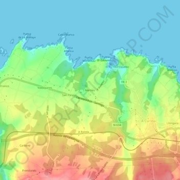
Name: Mernes topographic map, elevation, terrain.
Location: Mernes, El Franco, Asturias, 33746, España (43.53778 -6.86692 43.57778 -6.82692)
Average elevation: 125 ft
Minimum elevation: -3 ft
Maximum elevation: 331 ft
Thank you for supporting this site ❤️
Make a donation
Make a donation
Gear up for your next adventure:
As an Amazon Associate, this site earns from qualifying purchases at no extra cost to you.
Other topographic maps
Click on a map to view its topography, its elevation and its terrain.
Villalmarzo
La aldea se sitúa a una altitud de 200 m y dista 7,5 km de la villa de La Caridad, capital del concejo.
Average elevation: 610 ft