
Make a donation
Gear up for your next adventure:
As an Amazon Associate, this site earns from qualifying purchases at no extra cost to you.
Arçais topographic map
Click on the map to display elevation.
Make a donation
Gear up for your next adventure:
As an Amazon Associate, this site earns from qualifying purchases at no extra cost to you.
About this map
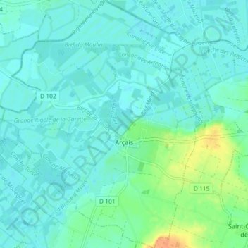
Name: Arçais topographic map, elevation, terrain.
Average elevation: 23 ft
Minimum elevation: 0 ft
Maximum elevation: 115 ft
Make a donation
Gear up for your next adventure:
As an Amazon Associate, this site earns from qualifying purchases at no extra cost to you.
Other topographic maps
Click on a map to view its topography, its elevation and its terrain.
La Blinière
France > Nouvelle-Aquitaine > Deux-Sèvres > Saint Maurice Étusson
Average elevation: 486 ft
Make a donation
Gear up for your next adventure:
As an Amazon Associate, this site earns from qualifying purchases at no extra cost to you.
L'Oignon
France > Nouvelle-Aquitaine > Deux-Sèvres > Saint-Martin-de-Bernegoue
Average elevation: 141 ft
Make a donation
Gear up for your next adventure:
As an Amazon Associate, this site earns from qualifying purchases at no extra cost to you.
Le Puy Thareau
France > Nouvelle-Aquitaine > Deux-Sèvres > Saint-André-sur-Sèvre
Average elevation: 571 ft
Make a donation
Gear up for your next adventure:
As an Amazon Associate, this site earns from qualifying purchases at no extra cost to you.
Make a donation
Gear up for your next adventure:
As an Amazon Associate, this site earns from qualifying purchases at no extra cost to you.
Make a donation
Gear up for your next adventure:
As an Amazon Associate, this site earns from qualifying purchases at no extra cost to you.
Château de Melzéard
France > Nouvelle-Aquitaine > Deux-Sèvres > Melle > Melzéard
Average elevation: 331 ft
Château de Saint-Loup sur Thouet
France > Nouvelle-Aquitaine > Deux-Sèvres > Saint-Loup-Lamairé > Le Faubourg
Average elevation: 361 ft
Make a donation
Gear up for your next adventure:
As an Amazon Associate, this site earns from qualifying purchases at no extra cost to you.
Crouzon
France > Nouvelle-Aquitaine > Deux-Sèvres > Beaussais-Vitré > Beaussais
Average elevation: 479 ft
Make a donation
Gear up for your next adventure:
As an Amazon Associate, this site earns from qualifying purchases at no extra cost to you.
Make a donation
Gear up for your next adventure:
As an Amazon Associate, this site earns from qualifying purchases at no extra cost to you.
Champdeniers
France > Nouvelle-Aquitaine > Deux-Sèvres > Champdeniers > Champdeniers
Average elevation: 361 ft
Make a donation
Gear up for your next adventure:
As an Amazon Associate, this site earns from qualifying purchases at no extra cost to you.
La Chatte
France > Nouvelle-Aquitaine > Deux-Sèvres > Frontenay-Rohan-Rohan > La Grande Grange
Average elevation: 46 ft
Make a donation
Gear up for your next adventure:
As an Amazon Associate, this site earns from qualifying purchases at no extra cost to you.
Champbertrand
France > Nouvelle-Aquitaine > Deux-Sèvres > Villiers-en-Plaine
Average elevation: 187 ft
Bief du Four a Chaux
France > Nouvelle-Aquitaine > Deux-Sèvres > Le Vanneau-Irleau > Irleau
Average elevation: 16 ft
Make a donation
Gear up for your next adventure:
As an Amazon Associate, this site earns from qualifying purchases at no extra cost to you.
Make a donation
Gear up for your next adventure:
As an Amazon Associate, this site earns from qualifying purchases at no extra cost to you.
Make a donation
Gear up for your next adventure:
As an Amazon Associate, this site earns from qualifying purchases at no extra cost to you.
Make a donation
Gear up for your next adventure:
As an Amazon Associate, this site earns from qualifying purchases at no extra cost to you.
La Prairie de Confolans
France > Nouvelle-Aquitaine > Deux-Sèvres > Saint-Symphorien > Chantigne
Average elevation: 43 ft
Make a donation
Gear up for your next adventure:
As an Amazon Associate, this site earns from qualifying purchases at no extra cost to you.
Terrier de Saint-Martin-du-Fouilloux
France > Nouvelle-Aquitaine > Deux-Sèvres > Saint-Martin-du-Fouilloux
Average elevation: 745 ft
Make a donation
Gear up for your next adventure:
As an Amazon Associate, this site earns from qualifying purchases at no extra cost to you.
Make a donation
Gear up for your next adventure:
As an Amazon Associate, this site earns from qualifying purchases at no extra cost to you.
Parc Saint-Hubert
France > Nouvelle-Aquitaine > Deux-Sèvres > Nueil-les-Aubiers
Average elevation: 453 ft
Make a donation
Gear up for your next adventure:
As an Amazon Associate, this site earns from qualifying purchases at no extra cost to you.
Les Brandes de Six Ailes
France > Nouvelle-Aquitaine > Deux-Sèvres > Bressuire
Average elevation: 545 ft
Make a donation
Gear up for your next adventure:
As an Amazon Associate, this site earns from qualifying purchases at no extra cost to you.
Make a donation
Gear up for your next adventure:
As an Amazon Associate, this site earns from qualifying purchases at no extra cost to you.
Make a donation
Gear up for your next adventure:
As an Amazon Associate, this site earns from qualifying purchases at no extra cost to you.
Saint-Martin
France > Nouvelle-Aquitaine > Deux-Sèvres > Fontenille-Saint-Martin-d'Entraigues
Average elevation: 282 ft
Le Champ du Parc
France > Nouvelle-Aquitaine > Deux-Sèvres > La Mothe-Saint-Héray
Average elevation: 335 ft
Les Segeliers
France > Nouvelle-Aquitaine > Deux-Sèvres > Sauzé-Vaussais > Sauzé
Average elevation: 476 ft
Make a donation
Gear up for your next adventure:
As an Amazon Associate, this site earns from qualifying purchases at no extra cost to you.
Les Roches Neulons
France > Nouvelle-Aquitaine > Deux-Sèvres > Nueil-les-Aubiers
Average elevation: 423 ft
Make a donation
Gear up for your next adventure:
As an Amazon Associate, this site earns from qualifying purchases at no extra cost to you.
Les Quatres Routes
France > Nouvelle-Aquitaine > Deux-Sèvres > La Chapelle-Saint-Laurent
Average elevation: 627 ft
Prairie de Saint-Rémis
France > Nouvelle-Aquitaine > Deux-Sèvres > Niort > La Moucherie
Average elevation: 39 ft
Make a donation
Gear up for your next adventure:
As an Amazon Associate, this site earns from qualifying purchases at no extra cost to you.
La Bidolière
France > Nouvelle-Aquitaine > Deux-Sèvres > Saint-Martin-de-Saint-Maixent
Average elevation: 292 ft
Make a donation
Gear up for your next adventure:
As an Amazon Associate, this site earns from qualifying purchases at no extra cost to you.