Geolocate

Berryton topographic map

Click on the map to display elevation.

About this map

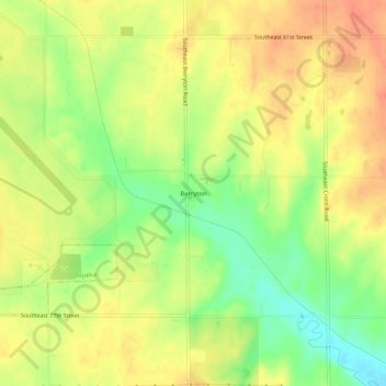
Name: Berryton topographic map, elevation, terrain.

Location: Berryton, Shawnee County, Kansas, 66409, United States (38.92084 -95.65165 38.96084 -95.61165)

Average elevation: 1,033 ft

Minimum elevation: 938 ft

Maximum elevation: 1,099 ft

Shawnee County trails, hiking, mountain biking, running and outdoor activities

Other topographic maps

Click on a map to view its topography, its elevation and its terrain.

Rossville

United States > Kansas > Shawnee County

Average elevation: 935 ft

Willard

United States > Kansas > Shawnee County

Average elevation: 951 ft

Silver Lake

United States > Kansas > Shawnee County

Average elevation: 912 ft

Gear up for your next adventure:

📡Handheld GPS Device - Reliable handheld GPS for outdoor navigation
💧Water Purification System - Clean water on the trail with reliable purifiers
🩳Quick‑Dry Hiking Shorts - Comfortable and quick‑dry shorts for summer hiking
🪄Magnetic Compass - Accurate compass for navigation
🔥Camping Stove - Portable stove for camping and backcountry cooking

As an Amazon Associate, this site earns from qualifying purchases at no extra cost to you.