
Chobham topographic map
Click on the map to display elevation.
Chobham
The rolling basin below reaches lowest elevations of between 30 metres (98 ft) in the centre of the west and 20 metres (66 ft) where the rivers join in the centre of the east. The rivers at the western point are less than 100 metres (330 ft) apart; to the east end of the parish where the parish adjoins the landscape of the McLaren Technology Centre the rivers are finally merged along that boundary.
About this map
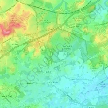
Name: Chobham topographic map, elevation, terrain.
Location: Chobham, Surrey Heath, Surrey, England, United Kingdom (51.33363 -0.64098 51.39246 -0.54851)
Average elevation: 141 ft
Minimum elevation: 62 ft
Maximum elevation: 325 ft
Other topographic maps
Click on a map to view its topography, its elevation and its terrain.
Camberley
United Kingdom > England > Surrey > Surrey Heath
The Staff College, to the north of Camberley town centre, is part of the Joint Services Command and Staff College, which provides training and education for established officers in the British Armed Forces and civil servants in the Ministry of Defence. The institution has its origins in the Royal Military…
Average elevation: 289 ft
Bagshot Park Mansion
United Kingdom > England > Surrey > Surrey Heath > Bagshot
Average elevation: 249 ft
Frimley Lodge Park
United Kingdom > England > Surrey > Surrey Heath > Frimley Green
Average elevation: 262 ft
Kalima Caravan Site
United Kingdom > England > Surrey > Surrey Heath > Chobham
Average elevation: 92 ft
Camberley
United Kingdom > England > Surrey > Surrey Heath
The Staff College, to the north of Camberley town centre, is part of the Joint Services Command and Staff College, which provides training and education for established officers in the British Armed Forces and civil servants in the Ministry of Defence. The institution has its origins in the Royal Military…
Average elevation: 289 ft