
Sedona topographic map
Interactive map
Click on the map to display elevation.
Sedona
Sedona interior chaparral has many shrubs and small tree species of Quercus turbinella and Rhus ovata and a large population of Quercus palmeri. The Great Basin woodland has many small to medium trees of Pinus monophylla Var. fallax, Juniperus arizonica, Juniperus deppeana, Juniperus osteosperma, and Juniperus monosperma and a large population of Cupressus glabra. At higher elevations in Oak Creek Canyon Juniperus virginiana, Pinus edulis and other pines occur.
About this map
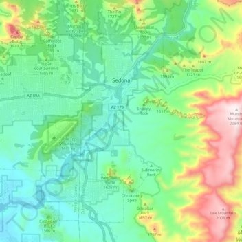
Name: Sedona topographic map, elevation, terrain.
Location: Sedona, Coconino County, Arizona, 86336, United States (34.81807 -111.84819 34.89021 -111.74289)
Average elevation: 4,403 ft
Minimum elevation: 3,743 ft
Maximum elevation: 6,332 ft
Coconino County trails, hiking, mountain biking, running and outdoor activities
Other topographic maps
Click on a map to view its topography, its elevation and its terrain.
Grand Canyon
United States > Arizona > Coconino County
Uplift associated with mountain formation later moved these sediments thousands of feet upward and created the Colorado Plateau. The higher elevation has also resulted in greater precipitation in the Colorado River drainage area, but not enough to change the Grand Canyon area from being semi-arid. The uplift…
Average elevation: 3,356 ft
Oak Creek Canyon
United States > Arizona > Coconino County
Oak Creek Canyon is about 12 miles (19 km) long, ranging in width from 0.8 to 2.5 miles (1.3 to 4.0 km). The depth of the canyon ranges from 800 to 2,000 feet (240 to 610 m). However, due to the faulting that played a major role in its formation, the west rim of the canyon is 700 feet (210 m) higher than the…
Average elevation: 6,099 ft
Cow Springs
United States > Arizona > Coconino County
Cow Springs is a populated place situated in Coconino County, Arizona, United States. It has an estimated elevation of 5,863 feet (1,787 m) above sea level.
Average elevation: 5,866 ft
Grand Canyon
United States > Arizona > Coconino County
Uplift associated with mountain formation later moved these sediments thousands of feet upward and created the Colorado Plateau. The higher elevation has also resulted in greater precipitation in the Colorado River drainage area, but not enough to change the Grand Canyon area from being semi-arid. The uplift…
Average elevation: 3,356 ft
Flagstaff
United States > Arizona > Coconino County
Flagstaff, the county seat of Coconino County. According to the United States Census Bureau, the city has a total area of 63.9 square miles (165.5 km2), of which only 0.03 square miles (0.08 km2) (0.08%) is water. Flagstaff lies at approximately 7,000 feet (2,130 m) elevation, and is surrounded by the largest…
Average elevation: 7,139 ft
Bitter Springs
United States > Arizona > Coconino County
The mean elevation is 5,115 feet (1,559 m) above sea level. The US Postal Service ZIP code is 86040.
Average elevation: 5,568 ft
Flagstaff
United States > Arizona > Coconino County > Flagstaff
Flagstaff, the county seat of Coconino County. According to the United States Census Bureau, the city has a total area of 63.9 square miles (165.5 km2), of which only 0.03 square miles (0.08 km2) (0.08%) is water. Flagstaff lies at approximately 7,000 feet (2,130 m) elevation, and is surrounded by the largest…
Average elevation: 7,316 ft
South Rim
United States > Arizona > Coconino County > Grand Canyon Village
Average elevation: 6,096 ft
Glen Canyon Dam
United States > Arizona > Coconino County
The Bureau of Reclamation favored the Echo Park site over Glen Canyon, because its narrow canyons and high elevation (more than 5,000 feet (1,500 m), as compared to 3,700 feet (1,100 m) at Glen Canyon) would lead to less evaporation. It said that building Echo Park Dam and a "low" Glen Canyon Dam would save…
Average elevation: 3,842 ft
Grand Canyon
United States > Arizona > Coconino County
Uplift associated with mountain formation later moved these sediments thousands of feet upward and created the Colorado Plateau. The higher elevation has also resulted in greater precipitation in the Colorado River drainage area, but not enough to change the Grand Canyon area from being semi-arid. The uplift…
Average elevation: 3,356 ft
Pima Point
United States > Arizona > Coconino County > Grand Canyon Village
Average elevation: 5,007 ft