
Simpsonville topographic map
Click on the map to display elevation.
Simpsonville
Simpsonville is located in southeastern Greenville County at 34°44′0″N 82°15′36″W / 34.73333°N 82.26000°W / 34.73333; -82.26000 (34.733375, -82.260001), between Mauldin to the northwest and Fountain Inn to the southeast. The center of town has an elevation of 866 feet (264 m) above sea level.
About this map
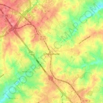
Name: Simpsonville topographic map, elevation, terrain.
Average elevation: 850 ft
Minimum elevation: 705 ft
Maximum elevation: 958 ft
Greenville County trails, hiking, mountain biking, running and outdoor activities
Other topographic maps
Click on a map to view its topography, its elevation and its terrain.
Marietta
United States > South Carolina > Greenville County > Slater-Marietta
Average elevation: 1,040 ft
Homestead Acres
United States > South Carolina > Greenville County > Taylors
Average elevation: 945 ft
Isaqueena Park
United States > South Carolina > Greenville County > Greenville
Average elevation: 974 ft
Cleveland Forest
United States > South Carolina > Greenville County > Greenville
Average elevation: 942 ft
Sherwood Forest
United States > South Carolina > Greenville County > Greenville
Average elevation: 961 ft
Sunny Acres
United States > South Carolina > Greenville County > Travelers Rest
Average elevation: 1,070 ft
Slater
United States > South Carolina > Greenville County > Slater-Marietta
Average elevation: 1,063 ft
Mount Vernon Estates
United States > South Carolina > Greenville County > Greer
Average elevation: 991 ft
Little Table Rock Mountain
United States > South Carolina > Greenville County
Average elevation: 2,927 ft
Piney Ridge
United States > South Carolina > Greenville County > Wade Hampton
Average elevation: 997 ft
Glenwood Acres
United States > South Carolina > Greenville County > Greenville
Average elevation: 1,001 ft
Morningside
United States > South Carolina > Greenville County > Wade Hampton
Average elevation: 984 ft
Orchard Acres
United States > South Carolina > Greenville County > Wade Hampton
Average elevation: 958 ft
Crescentwood Village
United States > South Carolina > Greenville County > Mauldin
Average elevation: 906 ft
Evergreen Place
United States > South Carolina > Greenville County > Greenville
Average elevation: 945 ft
Stone Lake
United States > South Carolina > Greenville County > Greenville
Average elevation: 1,001 ft