
Make a donation
Gear up for your next adventure:
As an Amazon Associate, this site earns from qualifying purchases at no extra cost to you.
Milan topographic map
Click on the map to display elevation.
Make a donation
Gear up for your next adventure:
As an Amazon Associate, this site earns from qualifying purchases at no extra cost to you.
Milan
The ancient Celtic settlement was, from a topographic point of view, superimposed and replaced by the Roman one. The Roman city was then gradually superimposed and replaced by the medieval one. The urban center of Milan has therefore grown constantly and rapidly, until modern times, around the first Celtic nucleus. The original Celtic toponym Medhelanon then changed, as evidenced by a graffiti in Celtic language present on a section of the Roman walls of Milan which dates back to a period following the Roman conquest of the Celtic village, in Mesiolano. In 286, the Roman Emperor Diocletian moved the capital of the Western Roman Empire from Rome to Mediolanum. Diocletian himself chose to reside at Nicomedia in the Eastern Empire, leaving his colleague Maximian at Milan.
Make a donation
Gear up for your next adventure:
As an Amazon Associate, this site earns from qualifying purchases at no extra cost to you.
About this map
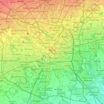
Name: Milan topographic map, elevation, terrain.
Location: Milan, Lombardy, Italy (45.38674 9.04089 45.53585 9.27811)
Average elevation: 400 ft
Minimum elevation: 285 ft
Maximum elevation: 561 ft
Make a donation
Gear up for your next adventure:
As an Amazon Associate, this site earns from qualifying purchases at no extra cost to you.
Other topographic maps
Click on a map to view its topography, its elevation and its terrain.
Make a donation
Gear up for your next adventure:
As an Amazon Associate, this site earns from qualifying purchases at no extra cost to you.
Make a donation
Gear up for your next adventure:
As an Amazon Associate, this site earns from qualifying purchases at no extra cost to you.