
Make a donation
Gear up for your next adventure:
As an Amazon Associate, this site earns from qualifying purchases at no extra cost to you.
Kathmandu topographic map
Click on the map to display elevation.
Make a donation
Gear up for your next adventure:
As an Amazon Associate, this site earns from qualifying purchases at no extra cost to you.
Kathmandu
Kathmandu, officially Kathmandu Metropolitan City, is the capital and most populous city of Nepal with 845,767 inhabitants living in 105,649 households in 2021 and 2.9 million people in its urban agglomeration. It is located in the Kathmandu Valley, a large valley in the high plateaus in central Nepal, at an altitude of 1,400 metres (4,600 feet).
Make a donation
Gear up for your next adventure:
As an Amazon Associate, this site earns from qualifying purchases at no extra cost to you.
About this map
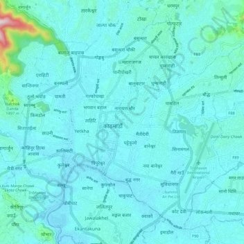
Name: Kathmandu topographic map, elevation, terrain.
Location: Kathmandu, Bagmati Pradesh, Nepal (27.66795 85.26809 27.75132 85.37348)
Average elevation: 4,380 ft
Minimum elevation: 4,183 ft
Maximum elevation: 6,650 ft
Make a donation
Gear up for your next adventure:
As an Amazon Associate, this site earns from qualifying purchases at no extra cost to you.
Other topographic maps
Click on a map to view its topography, its elevation and its terrain.