Geolocate

Cupar topographic map

Click on the map to display elevation.

About this map

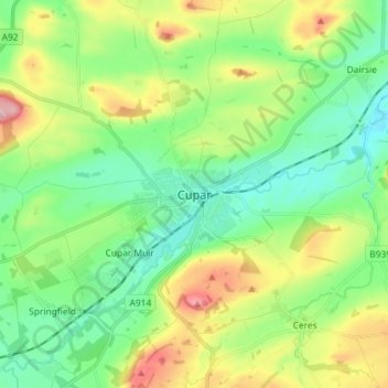
Name: Cupar topographic map, elevation, terrain.

Location: Cupar, Fife, Scotland, KY15 4BP, United Kingdom (56.27939 -3.05165 56.35939 -2.97165)

Average elevation: 246 ft

Minimum elevation: 16 ft

Maximum elevation: 738 ft

Other topographic maps

Click on a map to view its topography, its elevation and its terrain.

Rosyth

United Kingdom > Scotland > Fife

Average elevation: 75 ft

Auchtertool

United Kingdom > Scotland > Fife

Average elevation: 371 ft

Gear up for your next adventure:

🎒Trekking Poles - Sturdy poles for balance and stability on rough terrain
🧯Emergency Survival Kit - All‑in‑one survival essentials for the backcountry
🛶Inflatable Kayak - Portable kayak for rivers, lakes, and expeditions
🌧️Backpack Rain Cover - Keep gear dry in wet weather
🏫Relief Map Kits - Hands-on tools for teaching landforms and elevation

As an Amazon Associate, this site earns from qualifying purchases at no extra cost to you.