
Make a donation
Gear up for your next adventure:
As an Amazon Associate, this site earns from qualifying purchases at no extra cost to you.
The Yards Park topographic map
Click on the map to display elevation.
Make a donation
Gear up for your next adventure:
As an Amazon Associate, this site earns from qualifying purchases at no extra cost to you.
About this map
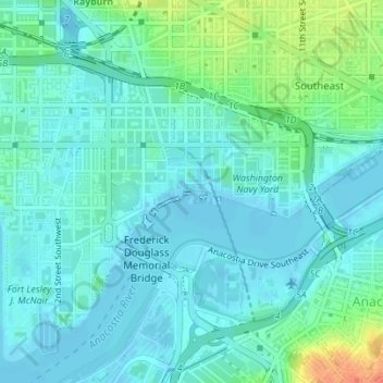
Name: The Yards Park topographic map, elevation, terrain.
Average elevation: 36 ft
Minimum elevation: -10 ft
Maximum elevation: 154 ft
District of Columbia trails, hiking, mountain biking, running and outdoor activities
Make a donation
Gear up for your next adventure:
As an Amazon Associate, this site earns from qualifying purchases at no extra cost to you.
Other topographic maps
Click on a map to view its topography, its elevation and its terrain.
Make a donation
Gear up for your next adventure:
As an Amazon Associate, this site earns from qualifying purchases at no extra cost to you.
Fort Reno Park
United States > District of Columbia > Washington
The highest natural elevation at Fort Reno, 409 feet (125 m), is lower than the top of the Washington Monument, which rises 555 feet (169 m) from nearly sea level.
Average elevation: 318 ft