
Make a donation
Gear up for your next adventure:
As an Amazon Associate, this site earns from qualifying purchases at no extra cost to you.
Betten topographic map
Click on the map to display elevation.
Make a donation
Gear up for your next adventure:
As an Amazon Associate, this site earns from qualifying purchases at no extra cost to you.
Betten
Die ehemalige Gemeinde bestand aus den Ortsteilen Dorf und Egga in Betten auf einer Terrasse des Rhonetals in 1200 m Höhe und der Bettmeralp im Aletschgebiet auf 1950 m Höhe. Diese kann nur über eine Luftseilbahn oder zu Fuss erreicht werden; die schmale Fahrstrasse ist nicht öffentlich. Die Bettmeralp liegt im Bereich der seit 2002 zum UNESCO-Weltnaturerbe erklärten Bergregion Jungfrau-Aletsch-Bietschhorn.
Make a donation
Gear up for your next adventure:
As an Amazon Associate, this site earns from qualifying purchases at no extra cost to you.
About this map
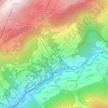
Name: Betten topographic map, elevation, terrain.
Location: Betten, Bettmeralp, Östlich Raron, Wallis, 3991, Schweiz (46.35643 8.04926 46.39643 8.08926)
Average elevation: 4,659 ft
Minimum elevation: 2,464 ft
Maximum elevation: 7,667 ft
Make a donation
Gear up for your next adventure:
As an Amazon Associate, this site earns from qualifying purchases at no extra cost to you.
Other topographic maps
Click on a map to view its topography, its elevation and its terrain.
Make a donation
Gear up for your next adventure:
As an Amazon Associate, this site earns from qualifying purchases at no extra cost to you.