
Spindale topographic map
Click on the map to display elevation.
About this map
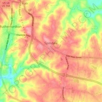
Name: Spindale topographic map, elevation, terrain.
Average elevation: 1,001 ft
Minimum elevation: 791 ft
Maximum elevation: 1,125 ft
Rutherford County trails, hiking, mountain biking, running and outdoor activities
Other topographic maps
Click on a map to view its topography, its elevation and its terrain.
Chimney Rock
United States > North Carolina > Rutherford County > Chimney Rock
Average elevation: 1,804 ft
Rutherfordton
United States > North Carolina > Rutherford County > Rutherfordton
Average elevation: 984 ft
Westminster
United States > North Carolina > Rutherford County > Westminster
Average elevation: 945 ft
James F. Crowe Memorial Park
United States > North Carolina > Rutherford County > Forest City > River Hills
Average elevation: 899 ft
Deerfield
United States > North Carolina > Rutherford County > Lake Lure > Deerfield
Average elevation: 1,647 ft