
Honoria topographic map
Click on the map to display elevation.
About this map
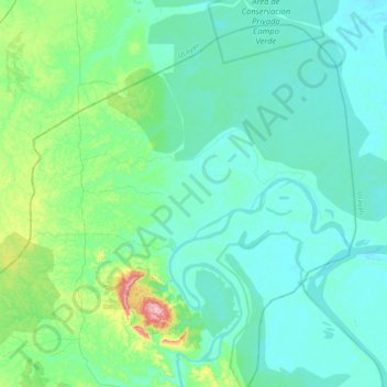
Name: Honoria topographic map, elevation, terrain.
Location: Honoria, Province of Puerto Inca, Huánuco, Peru (-8.88215 -74.91128 -8.54838 -74.52535)
Average elevation: 577 ft
Minimum elevation: 463 ft
Maximum elevation: 1,257 ft
Other topographic maps
Click on a map to view its topography, its elevation and its terrain.
La Bella Durmiente
La Bella Durmiente (Spanish for Sleeping Beauty), also known as Puma Ringri (possibly from Quechua puma cougar, puma, rinri ear, "puma ear"), is a mountain and prominent feature of Tingo María National Park, in the region of Huánuco, Peru. It is located in the district of Mariano Damaso, Leoncio Prado…
Average elevation: 2,877 ft
Tingo María
Tingo María was considered unreachable until 1936, when the Montaña Road reached the settlement. It was then that the state run Estacion Experimental Agricola was established due to its "comfortable" elevation (2,204 ft). In 1942, the U.S. Government began adding more funding to the station, and by 1960 over…
Average elevation: 2,759 ft
Tingo María
Tingo María was considered unreachable until 1936, when the Montaña Road reached the settlement. It was then that the state run Estacion Experimental Agricola was established due to its "comfortable" elevation (2,204 ft). In 1942, the U.S. Government began adding more funding to the station, and by 1960 over…
Average elevation: 2,743 ft
Tingo María
Tingo María was considered unreachable until 1936, when the Montaña Road reached the settlement. It was then that the state run Estacion Experimental Agricola was established due to its "comfortable" elevation (2,204 ft). In 1942, the U.S. Government began adding more funding to the station, and by 1960 over…
Average elevation: 2,759 ft
Tingo María
Tingo María was considered unreachable until 1936, when the Montaña Road reached the settlement. It was then that the state run Estacion Experimental Agricola was established due to its "comfortable" elevation (2,204 ft). In 1942, the U.S. Government began adding more funding to the station, and by 1960 over…
Average elevation: 2,654 ft