
Make a donation
Gear up for your next adventure:
As an Amazon Associate, this site earns from qualifying purchases at no extra cost to you.
Tangamandapio topographic map
Click on the map to display elevation.
Make a donation
Gear up for your next adventure:
As an Amazon Associate, this site earns from qualifying purchases at no extra cost to you.
About this map
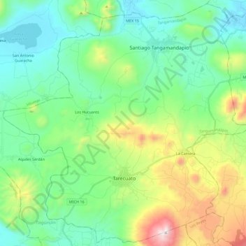
Name: Tangamandapio topographic map, elevation, terrain.
Location: Tangamandapio, Michoacán, Mexico (19.78903 -102.57370 19.99150 -102.35220)
Average elevation: 6,276 ft
Minimum elevation: 5,131 ft
Maximum elevation: 9,423 ft
Make a donation
Gear up for your next adventure:
As an Amazon Associate, this site earns from qualifying purchases at no extra cost to you.
Other topographic maps
Click on a map to view its topography, its elevation and its terrain.
Make a donation
Gear up for your next adventure:
As an Amazon Associate, this site earns from qualifying purchases at no extra cost to you.
Ihuatzio
Mexico > Michoacán > Tzintzuntzan
Ihuatzio is located on the southeast of the Lake Pátzcuaro, about 8 kilometers southwest of the town center of Tzintzuntzan. Its average elevation is 2,052 meters above the sea level.
Average elevation: 6,732 ft
Make a donation
Gear up for your next adventure:
As an Amazon Associate, this site earns from qualifying purchases at no extra cost to you.