Geolocate

Valea Borului topographic map

Interactive map

Click on the map to display elevation.

About this map

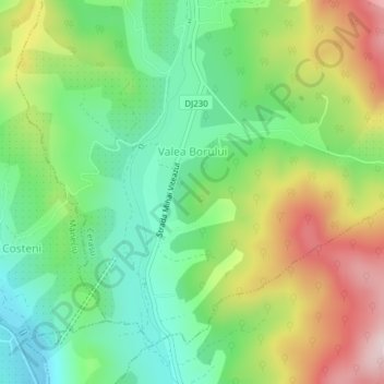
Name: Valea Borului topographic map, elevation, terrain.

Location: Valea Borului, Prahova, 107142, Romania (45.29339 26.03253 45.31253 26.06151)

Average elevation: 1,952 ft

Minimum elevation: 1,509 ft

Maximum elevation: 2,644 ft

Other topographic maps

Click on a map to view its topography, its elevation and its terrain.

Omu

Romania > Prahova > Bușteni

Omu, Bușteni, Prahova, Romania

Average elevation: 7,224 ft

Măneciu

Romania > Prahova

Măneciu, Prahova, Romania

Average elevation: 3,553 ft

Cerașu

Romania > Prahova

Cerașu, Prahova, 107140, Romania

Average elevation: 2,142 ft

Sinaia

Romania > Prahova

Sinaia, Prahova, 106100, Romania

Average elevation: 4,098 ft

Vâlcănești

Romania > Prahova

Vâlcănești, Prahova, Romania

Average elevation: 1,207 ft

Bușteni

Romania > Prahova

Bușteni, Prahova, Romania

Average elevation: 4,656 ft