Geolocate

Lillington topographic map

Click on the map to display elevation.

About this map

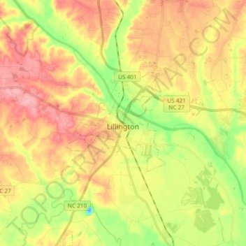
Name: Lillington topographic map, elevation, terrain.

Location: Lillington, Harnett County, North Carolina, United States (35.34002 -78.85429 35.46131 -78.76557)

Average elevation: 203 ft

Minimum elevation: -72 ft

Maximum elevation: 381 ft

Harnett County trails, hiking, mountain biking, running and outdoor activities

Other topographic maps

Click on a map to view its topography, its elevation and its terrain.

Rawls

United States > North Carolina > Harnett County

Average elevation: 335 ft

Bunnlevel

United States > North Carolina > Harnett County

Average elevation: 144 ft

Westhaven

United States > North Carolina > Harnett County > Dunn

Average elevation: 210 ft

Barbecue

United States > North Carolina > Harnett County

Average elevation: 285 ft

Bunnlevel

United States > North Carolina > Harnett County

Average elevation: 144 ft

Gear up for your next adventure:

🧥Men's Rain Shells - Premium waterproof and breathable jackets for mountain weather
Backpacking Tents - Weight-optimized shelters for multi-day topographic surveys
🥄Camping Utensil Set - Lightweight utensils for outdoor meals
🪓Survival Multi‑Tool - Versatile tool for camp and trail tasks
📷Action Cameras - Rugged cameras to document your journeys across rugged terrain

As an Amazon Associate, this site earns from qualifying purchases at no extra cost to you.