Geolocate

Barbecue topographic map

Click on the map to display elevation.

About this map

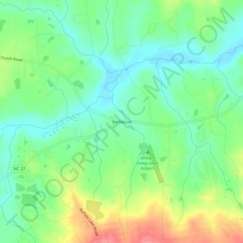
Name: Barbecue topographic map, elevation, terrain.

Location: Barbecue, Harnett County, North Carolina, United States (35.31599 -79.05864 35.35599 -79.01864)

Average elevation: 285 ft

Minimum elevation: 194 ft

Maximum elevation: 446 ft

Other topographic maps

Click on a map to view its topography, its elevation and its terrain.

Erwin

United States > North Carolina > Harnett County

Average elevation: 164 ft

Dunn

United States > North Carolina > Harnett County

Average elevation: 194 ft

Lillington

United States > North Carolina > Harnett County

Average elevation: 203 ft

Dunn

United States > North Carolina > Harnett County

Average elevation: 194 ft

Angier

United States > North Carolina > Harnett County

Average elevation: 299 ft

Lillington

United States > North Carolina > Harnett County

Average elevation: 203 ft

Gear up for your next adventure:

🏥Hiking First Aid Kits - Comprehensive medical kits for remote trail injuries
🎒Trail Energy Bars - High‑calorie bars for hiking energy
🧭Outdoor Navigation Book - Learn advanced navigation skills
🛶Inflatable Kayak - Portable kayak for rivers, lakes, and expeditions
📚Navigation Handbooks - Master the art of reading topographic maps and using a compass

As an Amazon Associate, this site earns from qualifying purchases at no extra cost to you.