
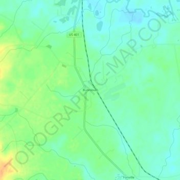
Bunnlevel topographic map
Click on the map to display elevation.
About this map
Name: Bunnlevel topographic map, elevation, terrain.
Location: Bunnlevel, Harnett County, North Carolina, United States (35.28961 -78.80030 35.32961 -78.76030)
Average elevation: 144 ft
Minimum elevation: 105 ft
Maximum elevation: 220 ft
Harnett County trails, hiking, mountain biking, running and outdoor activities
Other topographic maps
Click on a map to view its topography, its elevation and its terrain.
Raven Rock State Park
United States > North Carolina > Harnett County > Lillington
Average elevation: 259 ft