
Make a donation
Gear up for your next adventure:
As an Amazon Associate, this site earns from qualifying purchases at no extra cost to you.
Blair topographic map
Click on the map to display elevation.
Make a donation
Gear up for your next adventure:
As an Amazon Associate, this site earns from qualifying purchases at no extra cost to you.
About this map
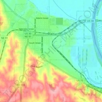
Name: Blair topographic map, elevation, terrain.
Location: Blair, Washington County, Nebraska, United States (41.50904 -96.16512 41.56189 -96.09471)
Average elevation: 1,125 ft
Minimum elevation: 978 ft
Maximum elevation: 1,378 ft
Washington County trails, hiking, mountain biking, running and outdoor activities
Make a donation
Gear up for your next adventure:
As an Amazon Associate, this site earns from qualifying purchases at no extra cost to you.
Other topographic maps
Click on a map to view its topography, its elevation and its terrain.
De Soto National Wildlife Refuge
United States > Nebraska > Washington County
Average elevation: 1,004 ft