
Make a donation
Gear up for your next adventure:
As an Amazon Associate, this site earns from qualifying purchases at no extra cost to you.
Capitán Bado topographic map
Click on the map to display elevation.
Make a donation
Gear up for your next adventure:
As an Amazon Associate, this site earns from qualifying purchases at no extra cost to you.
About this map
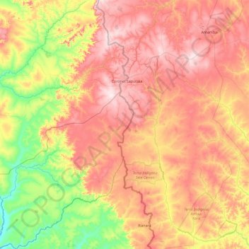
Name: Capitán Bado topographic map, elevation, terrain.
Location: Capitán Bado, Amambay, Región Oriental, Paraguay (-23.83090 -56.06988 -23.00202 -55.50446)
Average elevation: 1,201 ft
Minimum elevation: 472 ft
Maximum elevation: 1,969 ft
Make a donation
Gear up for your next adventure:
As an Amazon Associate, this site earns from qualifying purchases at no extra cost to you.
Other topographic maps
Click on a map to view its topography, its elevation and its terrain.
Parque Nacional Cerro Corá
Paraguay > Amambay > Pedro Juan Caballero
El Parque está rodeado por cerros de moderada o baja elevación, ya que se encuentra en la zona de la cordillera del Amambay. Los cerros Ponta Porã, Guazú, Tacuru Pytâ, Alambique, Cerro Corá, Miron, Tanqueria y Tangaro, junto a varios otros dan al paisaje una característica peculiar.
Average elevation: 942 ft
Pedro Juan Caballero
Paraguay > Amambay > Pedro Juan Caballero
La ciudad de Pedro Juan Caballero se halla asentada en una meseta de la Cordillera del Amambay, a unos 700 metros sobre el nivel del mar. La topografía del terreno se presenta sin accidentes considerables, presentando un aspecto agradable con suaves ondulaciones.
Average elevation: 1,827 ft
Make a donation
Gear up for your next adventure:
As an Amazon Associate, this site earns from qualifying purchases at no extra cost to you.