
Make a donation
Gear up for your next adventure:
As an Amazon Associate, this site earns from qualifying purchases at no extra cost to you.
Nyanza topographic map
Click on the map to display elevation.
Make a donation
Gear up for your next adventure:
As an Amazon Associate, this site earns from qualifying purchases at no extra cost to you.
About this map
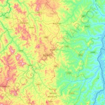
Name: Nyanza topographic map, elevation, terrain.
Location: Nyanza, Southern Province, Rwanda (-2.45464 29.58163 -2.23141 29.98479)
Average elevation: 5,279 ft
Minimum elevation: 4,419 ft
Maximum elevation: 7,001 ft
Make a donation
Gear up for your next adventure:
As an Amazon Associate, this site earns from qualifying purchases at no extra cost to you.
Other topographic maps
Click on a map to view its topography, its elevation and its terrain.
Make a donation
Gear up for your next adventure:
As an Amazon Associate, this site earns from qualifying purchases at no extra cost to you.
Kabgayi
Rwanda > Southern Province > Muhanga District > Nyamabuye
Kabgayi lies in the middle of Rwanda's central plateau at an elevation of about 6,000 feet (1,800 m) above sea level. Located in Kamazuru Village of Gahogo Cell in Nyamabuye Sector, it is a 5 minutes’ drive from Muhanga City. The community is just south of Gitarama, the second-largest city in Rwanda, and…
Average elevation: 6,020 ft
Make a donation
Gear up for your next adventure:
As an Amazon Associate, this site earns from qualifying purchases at no extra cost to you.