
Thank you for supporting this site ❤️
Make a donation
Make a donation
Gear up for your next adventure:
As an Amazon Associate, this site earns from qualifying purchases at no extra cost to you.
Bonampak topographic map
Click on the map to display elevation.
Thank you for supporting this site ❤️
Make a donation
Make a donation
Gear up for your next adventure:
As an Amazon Associate, this site earns from qualifying purchases at no extra cost to you.
About this map
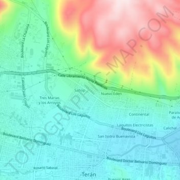
Name: Bonampak topographic map, elevation, terrain.
Location: Bonampak, Tuxtla Gutiérrez, Chiapas, 29025, México (16.75150 -93.18322 16.79150 -93.14322)
Average elevation: 2,221 ft
Minimum elevation: 1,791 ft
Maximum elevation: 3,186 ft
Thank you for supporting this site ❤️
Make a donation
Make a donation
Gear up for your next adventure:
As an Amazon Associate, this site earns from qualifying purchases at no extra cost to you.
Other topographic maps
Click on a map to view its topography, its elevation and its terrain.
Parque Jardines del Pedregal
México > Chiapas > Tuxtla Gutiérrez > Tuxtla Gutiérrez
Average elevation: 1,814 ft