
Make a donation
Gear up for your next adventure:
As an Amazon Associate, this site earns from qualifying purchases at no extra cost to you.
Cañón del Sumidero topographic map
Click on the map to display elevation.
Make a donation
Gear up for your next adventure:
As an Amazon Associate, this site earns from qualifying purchases at no extra cost to you.
About this map
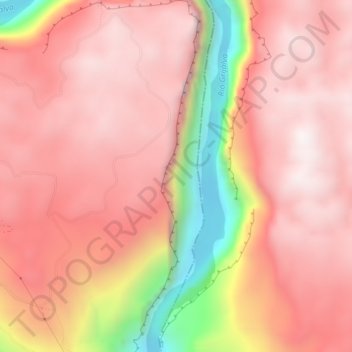
Name: Cañón del Sumidero topographic map, elevation, terrain.
Location: Cañón del Sumidero, Tuxtla Gutiérrez, Chiapas, México (16.79459 -93.08497 16.83588 -93.06593)
Average elevation: 3,609 ft
Minimum elevation: 1,227 ft
Maximum elevation: 4,642 ft
Make a donation
Gear up for your next adventure:
As an Amazon Associate, this site earns from qualifying purchases at no extra cost to you.
Other topographic maps
Click on a map to view its topography, its elevation and its terrain.
Laguitos Electricistas
México > Chiapas > Tuxtla Gutiérrez > Tuxtla Gutiérrez
Average elevation: 2,080 ft
Make a donation
Gear up for your next adventure:
As an Amazon Associate, this site earns from qualifying purchases at no extra cost to you.