
Make a donation
Gear up for your next adventure:
As an Amazon Associate, this site earns from qualifying purchases at no extra cost to you.
Thomas topographic map
Click on the map to display elevation.
Make a donation
Gear up for your next adventure:
As an Amazon Associate, this site earns from qualifying purchases at no extra cost to you.
About this map
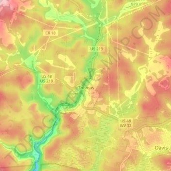
Name: Thomas topographic map, elevation, terrain.
Location: Thomas, Tucker County, West Virginia, 26292, United States (39.12820 -79.51006 39.17872 -79.46686)
Average elevation: 3,100 ft
Minimum elevation: 2,808 ft
Maximum elevation: 3,320 ft
Tucker County trails, hiking, mountain biking, running and outdoor activities
Make a donation
Gear up for your next adventure:
As an Amazon Associate, this site earns from qualifying purchases at no extra cost to you.
Other topographic maps
Click on a map to view its topography, its elevation and its terrain.
Davis
United States > West Virginia > Tucker County > Davis
At an elevation of 3,520 feet, Davis has the highest elevation of any West Virginia town.
Average elevation: 3,228 ft
Canaan Valley Resort State Park
United States > West Virginia > Tucker County
Average elevation: 3,389 ft
Make a donation
Gear up for your next adventure:
As an Amazon Associate, this site earns from qualifying purchases at no extra cost to you.
Make a donation
Gear up for your next adventure:
As an Amazon Associate, this site earns from qualifying purchases at no extra cost to you.
Canaan Valley Resort State Park
United States > West Virginia > Tucker County
Average elevation: 3,389 ft