
Make a donation
Gear up for your next adventure:
As an Amazon Associate, this site earns from qualifying purchases at no extra cost to you.
Essenbeek topographic map
Click on the map to display elevation.
Make a donation
Gear up for your next adventure:
As an Amazon Associate, this site earns from qualifying purchases at no extra cost to you.
About this map
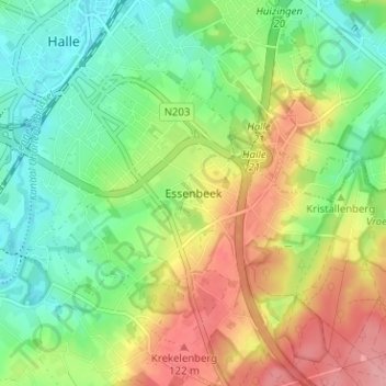
Name: Essenbeek topographic map, elevation, terrain.
Location: Essenbeek, Halle, Halle-Vilvoorde, Vlaams-Brabant, 1501, België (50.70031 4.23875 50.74031 4.27875)
Average elevation: 236 ft
Minimum elevation: 98 ft
Maximum elevation: 436 ft
Make a donation
Gear up for your next adventure:
As an Amazon Associate, this site earns from qualifying purchases at no extra cost to you.
Other topographic maps
Click on a map to view its topography, its elevation and its terrain.
Buizingen
België > Vlaams-Brabant > Halle-Vilvoorde > Halle
Buizingen ligt in een verstedelijkt gebied. De hoogte bedraagt 24-110 meter. Buizingen ligt aan de Zenne en aan het Kanaal Brussel-Charleroi. Een autosnelweg en een spoorlijn zijn eveneens elementen van de infrastructuur. Middenin Buizingen vindt men het Kluisbos. Daarnaast is ook het Krabbos van belang.
Average elevation: 167 ft
Lembeek
België > Vlaams-Brabant > Halle-Vilvoorde > Halle
Lembeek ligt op een hoogte van 32-127 meter. Het ligt aan de Zenne en aan het Kanaal Brussel-Charleroi. Aan de Zenne ligt het Kasteelpark. In het zuidoosten ligt het Lembeekbos en in het oosten het Maasdalbos. Dan is er nog het natuurgebied Berendries
Average elevation: 207 ft
Hallerbos
België > Vlaams-Brabant > Halle-Vilvoorde > Halle
Het landschap van het Hallerbos wordt bepaald door een vrij vlak massief van ongeveer 120 m hoogte, en is van noord naar zuid doorsneden door vijf valleitjes, met in de dalen opborrelende bronnen. De heuvelkammen zijn bedekt met leemlagen en de steile hellingen met dikke zandlagen. Dankzij de bebossing zijn er…
Average elevation: 322 ft
Make a donation
Gear up for your next adventure:
As an Amazon Associate, this site earns from qualifying purchases at no extra cost to you.
Lembeek
België > Vlaams-Brabant > Halle-Vilvoorde > Halle
Lembeek ligt op een hoogte van 32-127 meter. Het ligt aan de Zenne en aan het Kanaal Brussel-Charleroi. Aan de Zenne ligt het Kasteelpark. In het zuidoosten ligt het Lembeekbos en in het oosten het Maasdalbos. Dan is er nog het natuurgebied Berendries
Average elevation: 207 ft