
Make a donation
Gear up for your next adventure:
As an Amazon Associate, this site earns from qualifying purchases at no extra cost to you.
Hallerbos topographic map
Click on the map to display elevation.
Make a donation
Gear up for your next adventure:
As an Amazon Associate, this site earns from qualifying purchases at no extra cost to you.
Hallerbos
Het landschap van het Hallerbos wordt bepaald door een vrij vlak massief van ongeveer 120 m hoogte, en is van noord naar zuid doorsneden door vijf valleitjes, met in de dalen opborrelende bronnen. De heuvelkammen zijn bedekt met leemlagen en de steile hellingen met dikke zandlagen. Dankzij de bebossing zijn er sedert de laatste ijstijd weinig wijzigingen opgetreden in dit afwisselende reliëf. De oudste wegen in het bos hebben zich op enkele plaatsen ontwikkeld tot diep ingesneden holle wegen.
Make a donation
Gear up for your next adventure:
As an Amazon Associate, this site earns from qualifying purchases at no extra cost to you.
About this map
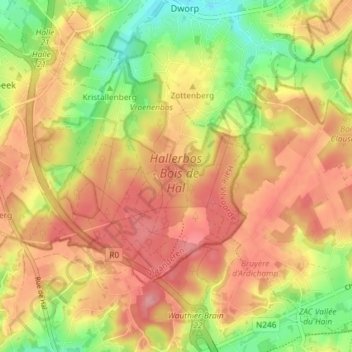
Name: Hallerbos topographic map, elevation, terrain.
Average elevation: 322 ft
Minimum elevation: 131 ft
Maximum elevation: 459 ft
Make a donation
Gear up for your next adventure:
As an Amazon Associate, this site earns from qualifying purchases at no extra cost to you.
Other topographic maps
Click on a map to view its topography, its elevation and its terrain.
Make a donation
Gear up for your next adventure:
As an Amazon Associate, this site earns from qualifying purchases at no extra cost to you.
Make a donation
Gear up for your next adventure:
As an Amazon Associate, this site earns from qualifying purchases at no extra cost to you.