
Braddock topographic map
Interactive map
Click on the map to display elevation.
Braddock
According to the U.S. Census Bureau, the borough has a total area of 0.6 square miles (1.6 km2), 0.6 square miles (1.6 km2) of which is land and 0.1 square miles (0.26 km2) (13.85%) of which is water. Its average elevation is 764 ft (233 m) above sea level.
About this map
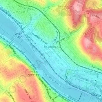
Name: Braddock topographic map, elevation, terrain.
Location: Braddock, Allegheny County, Pennsylvania, United States (40.39237 -79.87941 40.41196 -79.85874)
Average elevation: 902 ft
Minimum elevation: 719 ft
Maximum elevation: 1,227 ft
Allegheny County trails, hiking, mountain biking, running and outdoor activities
Other topographic maps
Click on a map to view its topography, its elevation and its terrain.
Champion
United States > Pennsylvania > Allegheny County > North Fayette Township
Average elevation: 1,181 ft
Monroe Heights
United States > Pennsylvania > Allegheny County > Monroeville
Average elevation: 1,083 ft
Allison Park
United States > Pennsylvania > Allegheny County > Hampton Township
Average elevation: 1,063 ft
Observatory Hill
United States > Pennsylvania > Allegheny County > Pittsburgh
Average elevation: 1,047 ft
Mustard
United States > Pennsylvania > Allegheny County > Elizabeth Township
Average elevation: 1,017 ft
Allegheny River Lock and Dam No. 2
United States > Pennsylvania > Allegheny County > O'Hara Township
Average elevation: 879 ft
Stoneybrooke Woods
United States > Pennsylvania > Allegheny County > Cheswick
Average elevation: 928 ft
Highland Park Reservoir No. 2
United States > Pennsylvania > Allegheny County > Pittsburgh
Average elevation: 902 ft
Lovedale
United States > Pennsylvania > Allegheny County > Elizabeth Township
Average elevation: 978 ft
Cochrans Mill
United States > Pennsylvania > Allegheny County > Jefferson Hills
Average elevation: 1,020 ft
Gibsonia
United States > Pennsylvania > Allegheny County > Richland Township
Average elevation: 1,142 ft
Neville Island
United States > Pennsylvania > Allegheny County > Neville Township
Average elevation: 948 ft
Dorseyville
United States > Pennsylvania > Allegheny County > Indiana Township
Average elevation: 1,066 ft
Glenwillard
United States > Pennsylvania > Allegheny County > Crescent Township > Glenwillard
Average elevation: 912 ft
Bakerstown
United States > Pennsylvania > Allegheny County > Richland Township
Average elevation: 1,168 ft
Fairoaks
United States > Pennsylvania > Allegheny County > Leet Township > Fairoaks
Average elevation: 883 ft
Carnot
United States > Pennsylvania > Allegheny County > Moon Township > Carnot
Average elevation: 1,102 ft
Clinton
United States > Pennsylvania > Allegheny County > Findlay Township > Clinton
Average elevation: 1,148 ft
Coverdale
United States > Pennsylvania > Allegheny County > Bethel Park > Coverdale
Average elevation: 1,161 ft