
Make a donation
Gear up for your next adventure:
As an Amazon Associate, this site earns from qualifying purchases at no extra cost to you.
Carthage topographic map
Click on the map to display elevation.
Make a donation
Gear up for your next adventure:
As an Amazon Associate, this site earns from qualifying purchases at no extra cost to you.
About this map
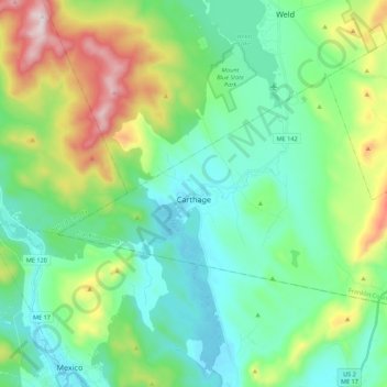
Name: Carthage topographic map, elevation, terrain.
Location: Carthage, Franklin County, Maine, 04224, United States (44.58018 -70.54999 44.67389 -70.33224)
Average elevation: 994 ft
Minimum elevation: 410 ft
Maximum elevation: 2,631 ft
Franklin County trails, hiking, mountain biking, running and outdoor activities
Make a donation
Gear up for your next adventure:
As an Amazon Associate, this site earns from qualifying purchases at no extra cost to you.
Other topographic maps
Click on a map to view its topography, its elevation and its terrain.
Make a donation
Gear up for your next adventure:
As an Amazon Associate, this site earns from qualifying purchases at no extra cost to you.
Sandy River Plantation
United States > Maine > Franklin County > Sandy River Plantation
Average elevation: 1,932 ft
Height of Land Scenic Overlook
United States > Maine > Franklin County > Township D > Rangeley Plantation
Average elevation: 1,972 ft
Make a donation
Gear up for your next adventure:
As an Amazon Associate, this site earns from qualifying purchases at no extra cost to you.