
Make a donation
Gear up for your next adventure:
As an Amazon Associate, this site earns from qualifying purchases at no extra cost to you.
FELDA Gedangsa topographic map
Click on the map to display elevation.
Make a donation
Gear up for your next adventure:
As an Amazon Associate, this site earns from qualifying purchases at no extra cost to you.
About this map
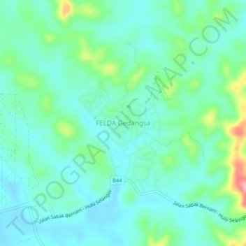
Name: FELDA Gedangsa topographic map, elevation, terrain.
Location: FELDA Gedangsa, Hulu Selangor, 44020, Malaysia (3.71934 101.36372 3.75934 101.40372)
Average elevation: 135 ft
Minimum elevation: 33 ft
Maximum elevation: 469 ft
Make a donation
Gear up for your next adventure:
As an Amazon Associate, this site earns from qualifying purchases at no extra cost to you.
Other topographic maps
Click on a map to view its topography, its elevation and its terrain.
Perak
In 1959, a British artillery officer stationed at an inland army base during the Malayan Emergency discovered the Tambun rock art, identified by archaeologists as the largest rock art site in the Malay Peninsula. Most of the paintings are located high above the cave floor, at an elevation of 6–10 metres…
Average elevation: 823 ft
Make a donation
Gear up for your next adventure:
As an Amazon Associate, this site earns from qualifying purchases at no extra cost to you.
Make a donation
Gear up for your next adventure:
As an Amazon Associate, this site earns from qualifying purchases at no extra cost to you.
Kelantan River
Malaysia > Kelantan > Kampung Paloh
The river's tributaries rise in the forested mountains in the Gua Musang region in southern Kelantan, where many Orang Asli tribes live. The area is known for its karst topography, dotted with mogotes with numerous caves beneath them. Some cave systems along the Nenggiri River, the river's left tributary, show…
Average elevation: 233 ft
Make a donation
Gear up for your next adventure:
As an Amazon Associate, this site earns from qualifying purchases at no extra cost to you.
Sabah
The jungles of Sabah host a diverse array of plant and animal species. Most of Sabah's biodiversity is located in the forest reserve areas, which formed half of its total landmass of 7.34 million hectares. Its forest reserve are part of the 20 million hectares equatorial rainforests demarcated under the "Heart…
Average elevation: 377 ft
Jelebu
Amongst the seven districts of Negeri Sembilan, Jelebu is the most mountainous topographically as the Titiwangsa Mountains, the longest mountain range in Malaysia, transverses through the district. As a result, most of its terrain are dominated by forested undulating hills and mountain peaks. The Titiwangsa…
Average elevation: 1,007 ft
Make a donation
Gear up for your next adventure:
As an Amazon Associate, this site earns from qualifying purchases at no extra cost to you.
Make a donation
Gear up for your next adventure:
As an Amazon Associate, this site earns from qualifying purchases at no extra cost to you.
Selayang Municipal Council
Malaysia > Selangor > Selayang Municipal Council
Given its varied topography pattern and close proximity to the Titiwangsa Mountains (Banjaran Titiwangsa), Selayang is a mix of urban and countryside sceneries. Its premier natural attraction, which is well-known across the country, is the Forest Research Institute Malaysia (FRIM), also known as FRIM Kepong.…
Average elevation: 774 ft
Make a donation
Gear up for your next adventure:
As an Amazon Associate, this site earns from qualifying purchases at no extra cost to you.
Make a donation
Gear up for your next adventure:
As an Amazon Associate, this site earns from qualifying purchases at no extra cost to you.
Make a donation
Gear up for your next adventure:
As an Amazon Associate, this site earns from qualifying purchases at no extra cost to you.
Make a donation
Gear up for your next adventure:
As an Amazon Associate, this site earns from qualifying purchases at no extra cost to you.
Make a donation
Gear up for your next adventure:
As an Amazon Associate, this site earns from qualifying purchases at no extra cost to you.