
Distrik Sela topographic map
Interactive map
Click on the map to display elevation.
About this map
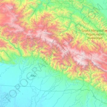
Name: Distrik Sela topographic map, elevation, terrain.
Location: Distrik Sela, Yahukimo, Papua, Indonesia (-5.21246 139.11272 -3.93246 140.39272)
Average elevation: 4,245 ft
Minimum elevation: 10 ft
Maximum elevation: 15,318 ft
Other topographic maps
Click on a map to view its topography, its elevation and its terrain.
Undundi-Wandandi
Undundi-Wandandi, Paniai, Papua, Indonesia
Average elevation: 10,449 ft
Maoke Mountains
Maoke Mountains, Trikora District, Jayawijaya, Papua, Indonesia
Average elevation: 9,377 ft
East Northwall Firn
East Northwall Firn, Mimika, Papua, Indonesia
Average elevation: 14,396 ft