
Maro topographic map
Interactive map
Click on the map to display elevation.
About this map
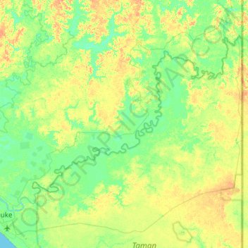
Name: Maro topographic map, elevation, terrain.
Location: Maro, Merauke, Papua, 99616, Indonesia (-8.47988 140.35068 -8.04274 140.98268)
Average elevation: 33 ft
Minimum elevation: -3 ft
Maximum elevation: 85 ft
Other topographic maps
Click on a map to view its topography, its elevation and its terrain.
Undundi-Wandandi
Undundi-Wandandi, Paniai, Papua, Indonesia
Average elevation: 10,449 ft
Maoke Mountains
Maoke Mountains, Trikora District, Jayawijaya, Papua, Indonesia
Average elevation: 9,377 ft
East Northwall Firn
East Northwall Firn, Mimika, Papua, Indonesia
Average elevation: 14,396 ft