Geolocate

Aroroy topographic map

Click on the map to display elevation.

About this map
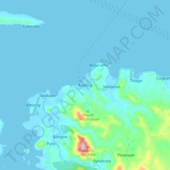
Name: Aroroy topographic map, elevation, terrain.

Location: Aroroy, Masbate, Bicol Region, 5414, Philippines (12.47233 123.35869 12.55233 123.43869)

Average elevation: 95 ft

Minimum elevation: -3 ft

Maximum elevation: 1,020 ft

Other topographic maps

Click on a map to view its topography, its elevation and its terrain.
Ticao Island

Philippines > Masbate

Average elevation: 75 ft

San Pascual

Philippines > Masbate

Average elevation: 23 ft

Bongsanglay Natural Park

Philippines > Masbate

Average elevation: 20 ft

Burias

Philippines > Masbate

Average elevation: 59 ft

Jintotolo Island

Philippines > Masbate > Jintotolo

Its elevation was recorded at around 120 feet (37 m) in 1919. A lighthouse with a tower at 51 feet (16 m) in height exists on Jintotolo island.

Average elevation: 20 ft

Sagawsawan River

Philippines > Masbate > Tabuc

Average elevation: 390 ft

Ticao Island

Philippines > Masbate

Average elevation: 75 ft

Burias

Philippines > Masbate

Average elevation: 59 ft

Manocmanoc Island

Philippines > Masbate

Average elevation: 0 ft

Ticao Island

Philippines > Masbate

Average elevation: 75 ft

Ticao Island

Philippines > Masbate

Average elevation: 75 ft

Masbate

Philippines > Masbate

Average elevation: 85 ft

Puro Islet

Philippines > Masbate > Pandan

Average elevation: 49 ft

Gilotongan

Philippines > Masbate

Average elevation: 0 ft

Gear up for your next adventure:

🧣Merino Neck Gaiters - Multi-functional headwear for wind and sun protection
🪶Compact Camp Shovel - Folding shovel for campsite tasks
🔋Rechargeable Batteries - Power up your outdoor devices
🥤Water Filter Bottle - All‑in‑one filter bottle for safe hydration
⛑️Personal Locator Beacon - Safety beacon for emergencies

As an Amazon Associate, this site earns from qualifying purchases at no extra cost to you.