Geolocate

Bergün Filisur topographic map

Click on the map to display elevation.

About this map
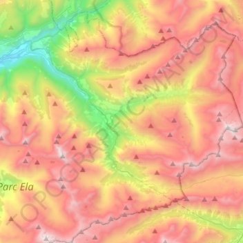
Name: Bergün Filisur topographic map, elevation, terrain.

Location: Bergün Filisur, Albula/Alvra, Grisons, Suisse (46.54993 9.64604 46.70072 9.88793)

Average elevation: 7,346 ft

Minimum elevation: 3,097 ft

Maximum elevation: 11,125 ft

Other topographic maps

Click on a map to view its topography, its elevation and its terrain.

Alvaneu Bad

Suisse > Grisons > Albula/Alvra > Albula/Alvra

Average elevation: 4,209 ft

Surava

Suisse > Grisons > Albula/Alvra > Albula/Alvra

Average elevation: 4,239 ft

Del

Suisse > Grisons > Albula/Alvra > Surses > Salouf

Average elevation: 4,590 ft

Latsch

Suisse > Grisons > Albula/Alvra > Bergün Filisur > Bergün/Bravuogn

Average elevation: 5,679 ft

Preda

Suisse > Grisons > Albula/Alvra > Bergün Filisur

Average elevation: 7,070 ft

Savognin

Suisse > Grisons > Albula/Alvra > Surses

Average elevation: 4,793 ft

Gear up for your next adventure:

👟Men's Trail Runners - Lightweight footwear for fast-paced exploration and light hiking
🪶Paracord Bracelet - Survival bracelet with built‑in tools
🪶Trail Camera - Capture wildlife on your hikes
🪑Portable Camp Table - Compact table for campsite meals
🔥Camping Stove - Portable stove for camping and backcountry cooking

As an Amazon Associate, this site earns from qualifying purchases at no extra cost to you.