
Make a donation
Gear up for your next adventure:
As an Amazon Associate, this site earns from qualifying purchases at no extra cost to you.
Merkem topographic map
Click on the map to display elevation.
Make a donation
Gear up for your next adventure:
As an Amazon Associate, this site earns from qualifying purchases at no extra cost to you.
Merkem
Merkem ligt op de westgrens van Zandlemig Vlaanderen, op een hoogte van 5 tot 10 meter. Ten westen daarvan bevindt zich de polderstreek, met de Sint-Jansbeek, de Ieperlee en de IJzer. In het noorden bevindt zich het broekgebied De Blankaart.
Make a donation
Gear up for your next adventure:
As an Amazon Associate, this site earns from qualifying purchases at no extra cost to you.
About this map
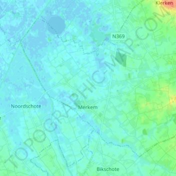
Name: Merkem topographic map, elevation, terrain.
Average elevation: 16 ft
Minimum elevation: -13 ft
Maximum elevation: 125 ft
Make a donation
Gear up for your next adventure:
As an Amazon Associate, this site earns from qualifying purchases at no extra cost to you.
Other topographic maps
Click on a map to view its topography, its elevation and its terrain.