Geolocate

Cristo Rey topographic map

Click on the map to display elevation.

About this map
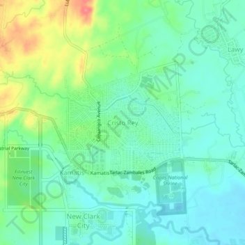
Name: Cristo Rey topographic map, elevation, terrain.

Location: Cristo Rey, Capas, Tarlac, Central Luzon, Philippines (15.34090 120.51705 15.38090 120.55705)

Average elevation: 246 ft

Minimum elevation: 174 ft

Maximum elevation: 410 ft

Other topographic maps

Click on a map to view its topography, its elevation and its terrain.
Tambo Lake

Philippines > Tarlac > Capas

Average elevation: 958 ft

O' Donnel River

Philippines > Tarlac > Capas

Average elevation: 728 ft

Capas National Shrine

Philippines > Tarlac > Capas > Cristo Rey

Average elevation: 210 ft

Gear up for your next adventure:

🔭Telescopic Hiking Pole - Adjustable pole for hiking stability
🏔️Mountain Trail Maps - High‑detail maps for popular peaks
🚁Photography Drones - Capture stunning aerial views of landforms and topography
🧼Biodegradable Camping Soap - Eco‑friendly soap for outdoor hygiene
🏥Hiking First Aid Kits - Comprehensive medical kits for remote trail injuries

As an Amazon Associate, this site earns from qualifying purchases at no extra cost to you.