
Općina Rovišće topographic map
Click on the map to display elevation.
About this map
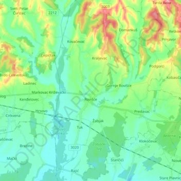
Name: Općina Rovišće topographic map, elevation, terrain.
Location: Općina Rovišće, Bjelovar-Bilogora County, Croatia (45.89204 16.69757 46.01147 16.81970)
Average elevation: 446 ft
Minimum elevation: 341 ft
Maximum elevation: 741 ft
Other topographic maps
Click on a map to view its topography, its elevation and its terrain.
Bjelovar
Croatia > Bjelovar-Bilogora County
The city of Bjelovar has an area of 181.75 km2 (70.2 sq mi), and administratively it includes 31 other areas. North-east of Bjelovar there is a long, low elevation called Bilogora, with an average height of 150–200 m (highest point: Rajčevica, 309 m). The geology of the area consists of Pliocene sandy marl…
Average elevation: 482 ft