
Make a donation
Gear up for your next adventure:
As an Amazon Associate, this site earns from qualifying purchases at no extra cost to you.
Huetamo topographic map
Click on the map to display elevation.
Make a donation
Gear up for your next adventure:
As an Amazon Associate, this site earns from qualifying purchases at no extra cost to you.
About this map
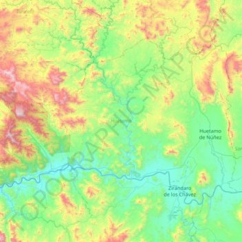
Name: Huetamo topographic map, elevation, terrain.
Location: Huetamo, Michoacán, Mexico (18.44324 -101.48545 18.87539 -100.82447)
Average elevation: 1,929 ft
Minimum elevation: 515 ft
Maximum elevation: 5,787 ft
Make a donation
Gear up for your next adventure:
As an Amazon Associate, this site earns from qualifying purchases at no extra cost to you.
Other topographic maps
Click on a map to view its topography, its elevation and its terrain.
Make a donation
Gear up for your next adventure:
As an Amazon Associate, this site earns from qualifying purchases at no extra cost to you.
Ihuatzio
Mexico > Michoacán > Tzintzuntzan
Ihuatzio is located on the southeast of the Lake Pátzcuaro, about 8 kilometers southwest of the town center of Tzintzuntzan. Its average elevation is 2,052 meters above the sea level.
Average elevation: 6,732 ft
Make a donation
Gear up for your next adventure:
As an Amazon Associate, this site earns from qualifying purchases at no extra cost to you.