
San Mateo topographic map
Interactive map
Click on the map to display elevation.
About this map
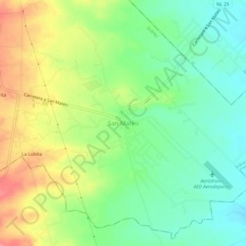
Name: San Mateo topographic map, elevation, terrain.
Location: San Mateo, Juárez, Nuevo León, 26296, México (25.51095 -100.11679 25.55095 -100.07679)
Average elevation: 1,352 ft
Minimum elevation: 1,247 ft
Maximum elevation: 1,503 ft
Other topographic maps
Click on a map to view its topography, its elevation and its terrain.
Cerro de La Silla
México > Nuevo León > Juárez > Monterrey
Cerro de La Silla, Monterrey, Juárez, Nuevo León, México
Average elevation: 2,890 ft
Río La Silla
México > Nuevo León > Juárez > Guadalupe
Río La Silla, Guadalupe, Juárez, Nuevo León, México
Average elevation: 1,942 ft
La Maestranza
México > Nuevo León > Juárez > San Roque > La Maestranza
La Maestranza, San Roque, Juárez, Nuevo León, 67254, México
Average elevation: 1,660 ft
Benito Juárez
México > Nuevo León > Juárez
Benito Juárez, Juárez, Nuevo León, 67250, México
Average elevation: 1,296 ft